General Information
Cases/Enablers
OOP Case
Appetizer
The Traffic information system (Tark Tee) provides information about road conditions, restrictions and road works. Tark Tee helps to plan a safe journey.
Short summary
The Traffic information system (Tark Tee) provides information about road conditions, restrictions and road works. Tark Tee helps to plan a safe journey. The Traffic Information centre is available through a toll free number. The system has modernised and integrated with apps like Waze. During the last years, a close cooperation with the Estonian capital city Tallinn has been created.
URL
Focus
Citizens
Start date
Domain
Public matter
Scope
National/Federal
Country
Estonia
Nature and status of project
Rolled Out
Is the OOP case/enabler mandatory?
Opt-in
ENABLING ASSETS OR COMPONENTS
Relevant Enablers
Political commitment
Traffic restrictions disclosure and traffic ban area permit and authorization procedures, RT I, 07.01.2015, 7, https://www.riigiteataja.ee/akt/107012015007
----------
Statute of the Road Administration, RT I, 06.03.2013, 19, https://www.riigiteataja.ee/akt/106032013019?leiaKehtiv
----------
Traffic Act, RT I 2010, 44, 261, https://www.riigiteataja.ee/akt/103012017018?leiaKehtiv
----------
Statute of the Road Administration, RT I, 06.03.2013, 19, https://www.riigiteataja.ee/akt/106032013019?leiaKehtiv
----------
Traffic Act, RT I 2010, 44, 261, https://www.riigiteataja.ee/akt/103012017018?leiaKehtiv
Socio-cultural influence factors
Smart Road provides better warning system for road users, it facilitates better management for traffic signs and better routing with operative information. By implementation of this system, road conditions and general information and restrictions are available from the same place for different users. Weather information and traffic frequency counter’s information updated every 15 minutes. And also, all restrictions published 48h before.
DATA HANDLING / DATA EXCHANGE
Type of data sharing
Actual data
Data handler
Stakeholder name
The Road Administration
Stakeholder category
Government
Stakeholder Role
Database owner
Kind of data
Traffic data
Stakeholder name
Road cameras
Stakeholder category
Government
Stakeholder Role
Data recorder
Kind of data
Traffic data
Stakeholder name
Road weather stations
Stakeholder category
Government
Stakeholder Role
Data recorder
Kind of data
Traffic data
Stakeholder name
Traffic sign management
Stakeholder category
Government
Stakeholder Role
Data controller
Kind of data
Traffic data
Stakeholder name
Road information center
Stakeholder category
Government
Stakeholder Role
Data controller
Kind of data
Traffic data
Stakeholder name
Citizens
Stakeholder category
Citizen
Stakeholder Role
Data consumer
Kind of data
Traffic data
Stakeholder name
Public administrations
Stakeholder category
Government
Stakeholder Role
Data consumer
Kind of data
Traffic data
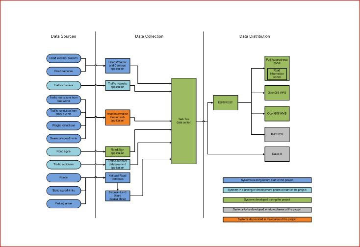
Architecture
• Public access allows viewing road information, such as road camera pictures, road weather, road works and speed slimits, routing system with special options for heacy and large vehicles.
• Authorized access allows submitting and managing information in the data center.
• Database is powered by PostGIS and ESRI ArcGIS Server.
• For example, all traffic signs are tagged with a QR code (containing information about the sign type, material, sign label etc). Whean a aign is installed on the road, it will be registered with the Smart road mobile app. App sends GPS coordinates to data center and receives list of roads nearby. Afetr confirming correct road, data from the QR code is sent to data center. If the sign is removed or damaged or temporarily disabled, it is visible through the app.
Linking registers
Data is provided from:
• road cameras
• traffic frequency counters
• road weather stations
• traffic sign management
• road information center
• accidents
• weight/speed limits
• parking areas
Image upload
Lessons learned
• Better warning system for road users
• Better management for traffic signs
• Better routing with operative information
• Good cooperation with Tallinn city and apps as Waze
• Covered all state roads
• Road conditions, general information and restrictions are available from the same time and place (coded and automatically) for different users (information systems and apps)
• Weather information and traffic frequency counters information updated every 15 minutes
• Restrictions published 48h before (at least the licenses will force)